


Coordinate Converter Plus

Description of Coordinate Converter Plus
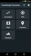
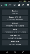
Coordinate Converter Plus is a coordinate converter and elevation calculator available for the Android platform. This app provides a range of functionalities for users who need to convert geographical coordinates and perform elevation calculations. It supports various coordinate formats, including Latitude/Longitude in decimal degrees, degrees decimal minutes, and degrees minutes seconds, as well as UTM and MGRS UTM formats.
The app includes a GPS converter that allows users to convert their current geographical location into different coordinate systems. This feature is particularly useful for outdoor activities such as hiking and geo-caching, where precise location data is essential. Users can switch between various formats to ensure they have the most appropriate data for their needs.
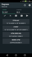
Latitude and Longitude conversion is another significant feature of Coordinate Converter Plus. Users can input their coordinates in multiple formats, making it easier to work with data gathered from different sources or devices. This capability enhances the app's versatility, catering to a wide range of user preferences and requirements. The ability to convert coordinates efficiently ensures that users can navigate effectively in unfamiliar areas.
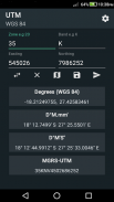
For users who work with UTM coordinates, the app provides a dedicated UTM converter. This feature allows for seamless transformation of UTM coordinates in both WGS84 and ARC 1950 datums. By supporting these widely used datums, the app functions as a reliable tool for professionals involved in surveying and mapping projects, as well as for outdoor enthusiasts.
MGRS conversion is another important aspect of Coordinate Converter Plus. The app enables users to easily convert coordinates into the Military Grid Reference System format, which is often utilized in military and defense applications. This feature adds to the app's functionality, allowing users to work with military-grade mapping standards when necessary.
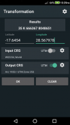
Datum transformation is a crucial feature that enhances the accuracy of coordinate conversions. Users can select from various datums to ensure that their geographical data aligns with established standards. This function is particularly valuable for professionals in fields such as cartography and geographic information systems (GIS), where precision is paramount.
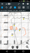
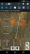
The app also provides access to maps, allowing users to visualize their coordinates and navigate their surroundings effectively. Users can convert map coordinates, which aids in planning routes or identifying specific locations on the map. The inclusion of map layers, such as points, polylines, and polygons, enables users to create detailed representations of their areas of interest.
Feature labels help users identify and differentiate various elements on the map, enhancing the overall user experience. By importing and exporting layers, users can easily share their projects with others or integrate data from different sources. This feature is particularly useful for collaborative projects, where multiple users may contribute to a single mapping endeavor.
Coordinate Converter Plus includes tools for calculating segment lengths for polylines and polygons. This functionality is beneficial for users who need to measure distances or assess the dimensions of specific areas. Additionally, the app allows for the calculation of polygon areas, providing users with essential data for land use planning and spatial analysis.
Distance and bearing calculations on the map are available, enabling users to determine the straight-line distance and direction between various points. This feature is especially useful for navigation, as it assists users in planning effective routes based on their desired destinations. The app’s digitizer functionality allows users to create map projects easily, ensuring that they can save and manage their work efficiently.
Automatic saving of projects is another practical aspect of Coordinate Converter Plus. This feature ensures that users do not lose their progress, providing peace of mind while working on important mapping tasks. Users can share their projects and coordinates with others, facilitating collaboration and communication within teams or among friends.
The ability to save locations and paste coordinates from the clipboard streamlines the process of managing geographical data. Users can quickly store important locations for future reference or input data from other applications, enhancing the app's usability. Furthermore, the import and export capabilities extend this functionality, allowing users to handle coordinates effectively across different platforms.
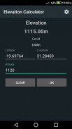
An elevation calculator is included in the app, which provides users with the ability to determine the elevation of specific points. This feature is particularly relevant for outdoor activities such as hiking and camping, where elevation changes can significantly impact planning and navigation. The app incorporates geoid altitude correction using the EGM96 model, ensuring that elevation data is accurate and reliable.
Coordinate Converter Plus serves multiple purposes, making it suitable for various applications such as mapping, geo-caching, hiking, camping, navigation, air rescue, and surveys. Its diverse features cater to both casual users and professionals alike, enhancing its appeal across different user groups. The combination of coordinate conversion, mapping capabilities, and elevation calculation positions this app as a valuable tool for anyone involved in geographic data management.
Coordinate Converter Plus - Version 144
(03-03-2025)
Coordinate Converter Plus - APK Information
APK Version: 144Package: com.tennyson.degrees2utmLatest Version of Coordinate Converter Plus
Other versions


Apps in the same category


